there are many situations where Bike Colorado Springs will take a stance on a topic, this is where you can find our stance on specific issues related safely navigiting our city by bicycle

Weber St Reconfiguration
Published 10-17-2018
The city has announced that they will modify Weber St, removing the parking protected bike lane from starting October 22, reconfiguring it with a buffered bike lane configuration between the travel lane and parked cars. While disappointed by the Mayor’s decision to remove this separated bicycle infrastructure, we are encouraged by the choice to keep the vehicle lane configuration, of a single lane in each direction, while including buffered bike lanes to provide safe routes for all people who use this roadway. We thank the mayor for his explanation of why he feels a change is necessary.
BCS agrees with the city’s efforts to evaluate new and innovative types of infrastructure in our city to improve transportation choices. Improved bicycle infrastructure will come to our community fastest if we are willing to try new things, and be willing to reconfigure if necessary, learning from our mistakes.
We applaud the city’s traffic engineering team for the completion of multiple critical bike connections throughout 2018, some of which were long missing. These connections were important especially since unconnected bikeways often see limited use. BCS will continue to advocate for the implementation of a broad, connected bicycle network, as outlined in our city’s newly adopted Bicycle Master Plan. This includes the continuation of bike lanes on Weber St north of Pikes Peak Ave into Downtown and through the Old North End.
NACTO Buffered bike lane Guidelines

BCS agrees with the city’s efforts to evaluate new and innovative types of infrastructure in our city to improve transportation choices. Improved bicycle infrastructure will come to our community fastest if we are willing to try new things, and be willing to reconfigure if necessary, learning from our mistakes.
We applaud the city’s traffic engineering team for the completion of multiple critical bike connections throughout 2018, some of which were long missing. These connections were important especially since unconnected bikeways often see limited use. BCS will continue to advocate for the implementation of a broad, connected bicycle network, as outlined in our city’s newly adopted Bicycle Master Plan. This includes the continuation of bike lanes on Weber St north of Pikes Peak Ave into Downtown and through the Old North End.
Parking Protected lanes - Weber (COS) vs 14th (Denver)
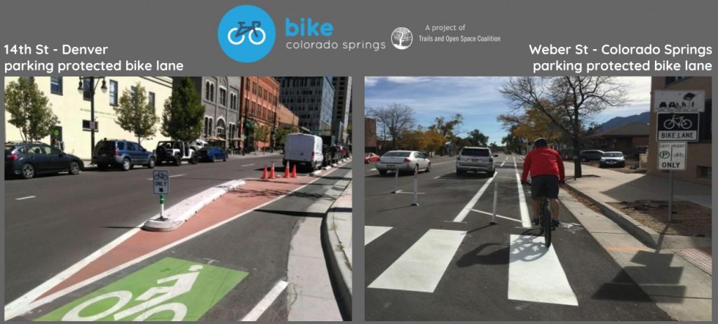
BCS continues to believe that on-street bicycle infrastructure that separates vehicle traffic from bicycle traffic is safest for all users and encourages more people to use bicycles as transportation. It is crucial that all traffic infrastructure be designed to make its use intuitive for all users. It is also imperative that communication about new types of infrastructure be clear at the time of implementation. The lessons learned from Weber street were used when the parking protected lanes on Pikes Peak were implemented. The lanes on Pikes Peak ave are a improvement from Webber, we strongly encourage our Traffic Engineers and Planners to continue this trend. We also encourage our city’s communication staff to implement more thorough user education and communication strategies on future projects.
We need to come together as city to support safety of all road users. We at BCS feel like we are close to the tipping point here in Colorado Springs but it will take a concerted effort for us to get there. We need businesses standing up saying “I need safe and effective transportation choices for my customers to access my store”. We need developers saying “I need better ways for my tenants to safely get around our growing city”. We need employers saying ”I need safe way for my employees to get to work”. And we need residents saying “ I need a safe way for me and my family to ride around Colorado Springs”
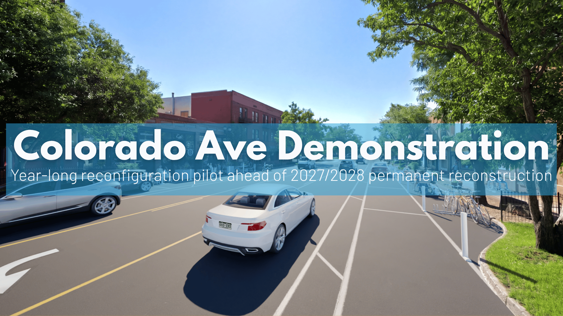
Colorado Avenue Demonstration: A Win for Safety, but a Missed Opportunity for Connectivity
Starting early summer 20226 (Update - June 1st 2026) the City of Colorado Springs is launching the 12-month Colorado Avenue Demonstration Project following the Midland Corridor Transportation Study. While we are encouraged by the focus on pedestrian safety and traffic calming, Bike Colorado Springs is deeply disappointed that this project continues to exclude safe, dedicated bicycle infrastructure on the Westside’s most vital corridor. Colorado Ave Project Midland Transport Study Survey LiveWhether you live nearby, own or work at a business, visit often, or travel through the area, your feedback will help the city understand current experiences on Colorado Ave and what should matter most as improvements move forward.Take the Colorado Ave Survey Here is the breakdown of what is coming, this is without a doubt a significant win for safety that we should be celebrating, at the same time we believe the current plan still falls short of its full potential - photos below are from the Colorado Ave Project Page A Missed Opportunity for the Westside Bike Colorado Springs believes that bike lanes on Colorado Ave make sense. Safe bike infrastructure on Colorado Ave would create an intuitive, direct, and safe connection between Downtown Colorado Springs, Old Colorado City, and Manitou Springs. Despite our continued advocacy, the City’s official Midland Corridor Transportation Study FAQ reveals a discouraging trade-off. When asked why the study doesn't recommend bike lanes on Colorado Avenue, the City’s response was clear: "Public input received during the study reflected a stronger desire for increased parking which was applied to Colorado Avenue..."Midland Corridor Transportation Study FAQ By prioritizing parking over safe bike connectivity, the City is missing a chance to build a truly multi-modal Main Street. We truly do understand the benefits of using lower traffic neighborhood streets like the City suggests. [Read here about the most recent bike boulevard meeting] But solely relying on side streets like Cucharras or Pikes Peak do have significant flaws: No Direct Merchant Access: Neither the Midland Trail or the side streets offer direct access to the shops, restaurants, and cafes on Colorado Ave. Riders shouldn't be "hidden" on backstreets when trying to support local businesses.The "Pikes Peak Hill": While Pikes Peak Ave is a designated route, it features a steep grade that is a major barrier for many riders.Waiting on Cucharras: We are still waiting for promised improvements on Cucharras, including a safe, signalized crossing at the high-traffic 21st Street intersection, which remains a dangerous gap in our network. The Positives: Celebrating a Safer Colorado Ave While we push for better bike access, there are significant safety improvements in this pilot that we should absolutely celebrate. These changes represent a major shift toward making Colorado Avenue a place for people: Lane Reconfiguration: Moving from 4 lanes to 3 (one travel lane each way plus a center turn lane) between Limit St and 29th St is a massive win for safety. This reconfiguration is a proven way to naturally calm speeding traffic while reducing left turn rear end crashes.Improved Pedestrian Crossings:…
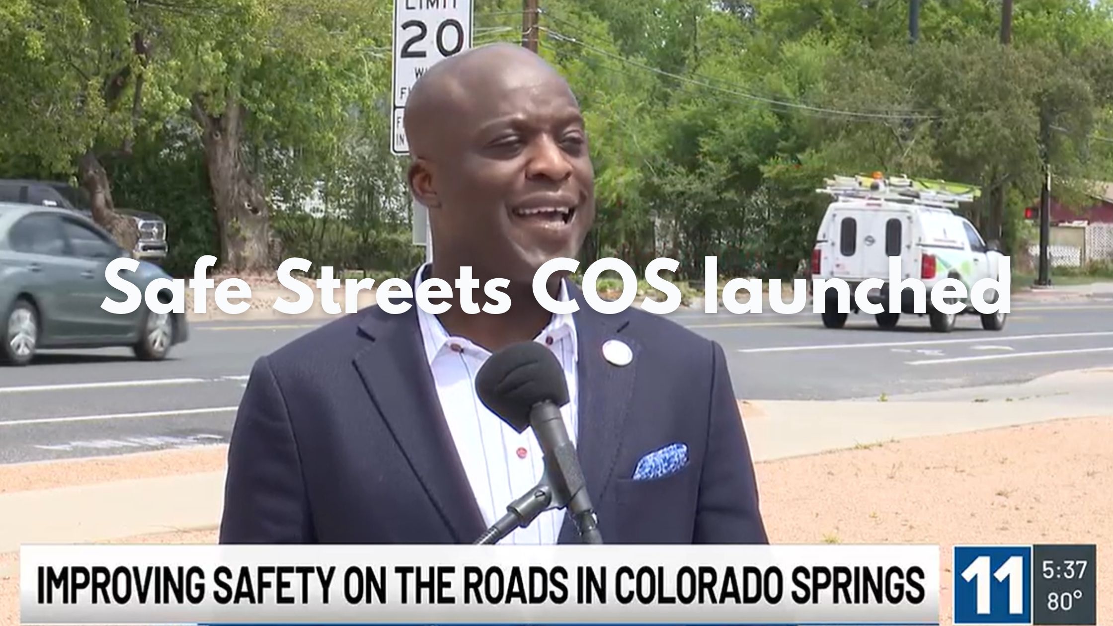
Safe Streets COS: Mayor Yemi Commits to a Safer, More Connected City
Last Wednesday Mayor Yemi officially kicked off the Safe Street COS initiative signaling a heartening shift in our city’s approach to transportation and transportation safety citywide - KKTV Article (header image from this reporting) Declaring, “Road safety is public safety", the mayor has committed to protecting lives on our roadways through smarter data and safer infrastructure. This builds on the city’s Transportation Safety Action Plan which was officially adopted by the Colorado Springs City Council this month (See the Bike COS safety action plan call to action here)This all comes back to our mission of Making bicycling in the Pikes Peak Region better for people of all ages and abilities. Nationally, the single biggest factor keeping people off their bikes isn’t a lack of interest, it’s a lack of safe connections. People want to ride, but when there are gaps in our comfortable bike network that make it feel unsafe they choose a car instead (See the 2025 Study on Infrastructure Roadblocks). 1. Bridging the Gaps Connectivity is at the core of what makes a city bikeable. Safe Streets COS focuses on “high-risk corridors” and trail crossings to ensure our network isn’t just a collection of paths, but a continuous, safe system. By treating these unsafe connections as a public safety priority, the city is clearing the path for more residents to choose a bike for daily trips or recreation. Safety Demonstration Projects (Implemented & Planned): Neighborhood traffic circles: To calm intersections in residential areas.Speed tables & Speed feedback signs: Proven tools to reduce speeding.Protected bike lanes: Physical separation to provide safe connections even on higher traffic streets. 2. Building Safe Connections for Kids The launch at Mann Middle highlighted our most vulnerable residents, our children, with a focus on school zones. By using engineering to slow speeding drivers, the city is making the connections our city’s kids use to walk and bike to class, the safe environments they should be. If we can make a middle schooler feel safe on their commute, we make the whole neighborhood safer for everyone.Link to Planned School Zone List 3. Data-Driven Transparency You can’t fix what you can’t see. As part of the city’s safety action plan, the city launched the Safe Streets Dashboard, an interactive tool that lets you explore crash trends in your own neighborhood. Making this data easily accessible allows us to see exactly where those unsafe connections are so we can advocate for the improvements needed to make all our residents safe. Explore the traffic safety dashboard the above is filtered to Bike and Pedestrian crashes The Goal: A 35% reduction in serious injury and fatal crashes by 2035. Explore the Data: ColoradoSprings.gov/SafeStreetsCOS
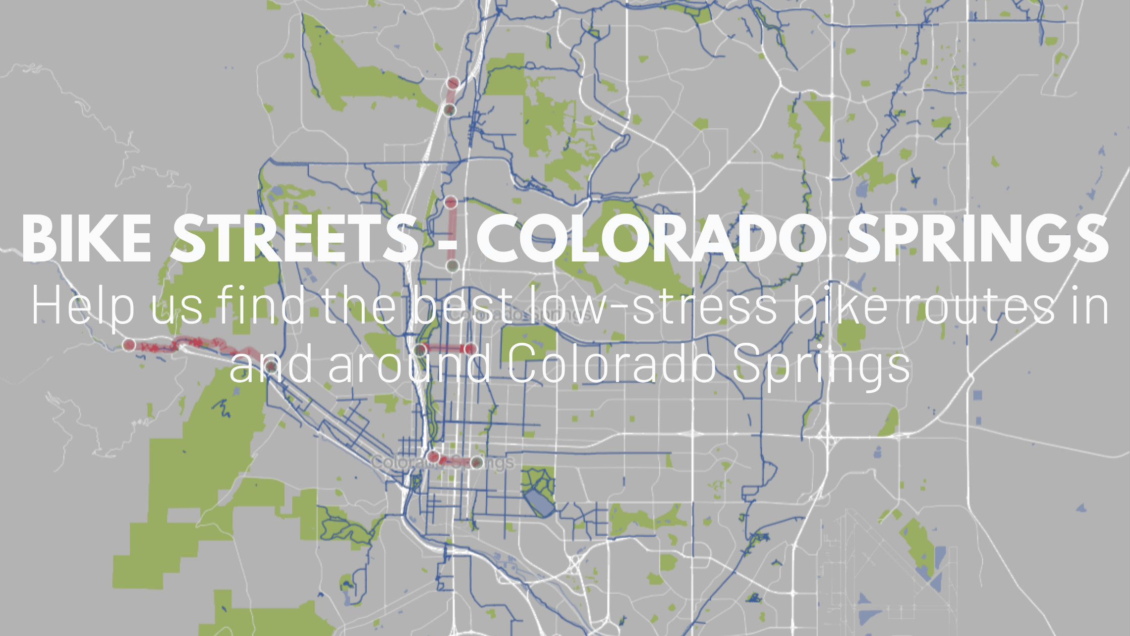
Bike Streets: Unlocking Hidden Connections in Colorado Springs
Bike Colorado Springs has officially started building out our city's Low-Stress Network partnering with the Colorado based Bike Streets team, unlocking hidden connections and safer routes in COS. We are excited to announce that we’ve already reached our first major milestone: 300 miles of comfortable, accessible routes are now live! Crowdsourcing Local Knowledge The real power of this tool is its ability to capture local knowledge that standard GPS apps often miss. We know that the best, safest routes aren't always the most obvious ones on a map. A truly low-stress connection often relies on "insider" info—like knowing you can connect through a specific alley or use a short sidewalk segment to link two quiet neighborhood streets. By mapping these non-obvious paths, we are creating a seamless web of routes that allows riders of all ages and abilities to navigate Colorado Springs with confidence. Join Bike Streets Download the app to add your favorite routes to our local map and start routing to your favorite destinations today. Help Us Map the Rest of the Springs While 300 miles is a fantastic start, we need your help to make this tool a resource for every neighborhood. We often think we have to wait for the city to build massive new projects before we can ride safely, but as Bike Streets founder Avi Stopper explains in his post on The Best Available Network, we can unlock the city today by identifying the best existing paths. By finding the quiet streets and hidden connectors that already exist but aren't on a standard map, we can build a world-class network right now. Check out this guide on How to Pick Streets for a Low-Stress Map to see the specific criteria we use, like low car volume and slow speeds, then help us find those "secret" cut-throughs, alleys, and quiet ways to reach the grocery store, the school, or the park. How you can contribute right now: Share Route Suggestions: Tell us about the "hidden" low-stress connections you use every day.Vote and Comment: Help us verify which routes feel the safest and which ones need a second look.Ride and Review: Use the tool for your next trip and let us know how it handles the real world. Connecting Trails and Streets Our work on Bike Streets focuses on creating a cohesive system. We are combining the best of our urban trails and open spaces with strategic on-street connections, like bike lanes and neighborhood greenways. The goal is to bridge the gaps so you can get across town without the stress of high-speed traffic. Get Involved with Bike Colorado Springs Making our city better for people on bikes takes a village. Beyond mapping, we have plenty of ways for you to lend your skills: Volunteer with Us: From helping at community events to assisting with communications and advocacy, we’re always looking for passionate people to join the team - Bike COS Volunteer PageStay Tuned: Keep an ear out for a community survey and engagement opportunities coming…

Back For 2026: Motorless Morning & Early Bird Hike and Bike
Motorless Mornings and Early Bird Hike & Bike events are back 2026, this is your chance to explore the Garden of The Gods' natural beauty in with only the sound of your tires or footsteps. Volunteers Needed We need your help! Bike Colorado Springs is coordinating volunteers for the Early Bird Hike and Bike at Garden of the Gods Park on Wednesday May 20, 2026 from 6am-8am. Volunteers aid in participant management and help keep everyone safe. Please consider signing up for a shift!Volunteer Sign-up Link Sign up to Volunteer Here Motorless MorningSunday April 26 2026 - 5 a.m. to 12 p.m.Sunday October 4 2026 - 5 a.m. to 12 p.m.Early Bird Hike and Bike3rd Wednesday of the month May - August 5am-8amMay 20June 24July 29August 26No registration needed to participate Motorless Mornings: This unique event offers a chance to experience the park's breathtaking beauty in a peaceful, car-free environment. It's the perfect opportunity to: Enjoy the serenity: Take in the stunning rock formations and natural landscapes without the noise and congestion of vehicles.Explore at your own pace: Hike, bike, jog, or simply stroll along the park's scenic trails at a leisurely pace.Connect with nature: Immerse yourself in the tranquility of the park and appreciate its diverse wildlife. City Motorless Morning Website Important Dates: Save the dates for the upcoming Motorless Mornings in 2026: Sunday, April 26th: The park will be open only to bike and foot traffic from 5:00 am to noon.Sunday, October 4: The second Motorless Morning will be held in October to end the season. Also from 5:00 am to noon. Early Bird Hike & Bike: For those seeking an even earlier car-free experience, the Early Bird Hike & Bike events offer exclusive access to the park's roads: Mark your calendars: These events take place on the last Wednesday of each month from May through August.2026 Dates: May 20th, June 24th, July 29th, August 26thTime: Enjoy the park from 5:00 am to 8:00 am. City Early Bird Hike & Bike Website Additional Information: Admission to the park is free during both Motorless Mornings and Early Bird Hike & Bike events.The Visitor Center will be open at 9:00 am on both dates for Motorless Mornings.Be sure to check the park's website for any updates or changes to the schedule closer to the event dates: https://coloradosprings.gov/motorlessmorning Get Involved! Volunteer opportunities are available for those who wish to help make these events a success. Volunteer Here We look forward to seeing you at Garden of the Gods Park for a memorable car-free experience! All park rules and regulations, including speed limits, apply; there will be designated slow zones and one-way traffic. The one exception to park rules is that skateboarding and longboarding are allowed on park roads during Motorless Morning but not on the Wednesday Early Bird Hike and Bike events. Visitors may encounter bicyclists and ebikers, hikers and runners, skateboards, and visitors with dogs. Please be considerate of others and share the trails and the road so everyone can have a safe and enjoyable time. Check out the rules of road and other…

Mesa Road Bridge Reconstruction: Monument Valley Connectivity Impacts
Big changes are coming to your commute and trail rides. Starting this month, a major rehabilitation project will temporarily close a key link in our network: the Cache la Poudre/Mesa Road bridge. We know this is a significant disruption for those who use this route to link the east and west sides of our historic core or to reach Colorado College, the Fine Arts Center, and the Pikes Peak Greenway. Here is the essential info on how to navigate the area during construction. The Impact: Closures & Detours Due to the complexity of this historic restoration, the project is expected to take 7 to 8 months. The Good News: We expect both the East and West sides of the Pikes Peak Greenway trails to remain open throughout construction. In the case that one side of The Pikes Peak Greenway Trail needs to close the other side will remain open and occasional detours will be posted as needed. Week of April 6: The Pikes Peak Greenway Trail (east side) Mesa Road underpass is now closed as crews begin work in the creek bed. The trail remains open via a well-marked detour around the construction zone.April 20: The bridge will close completely to all users—drivers, cyclists, and pedestrians. This closes the most direct route to the I-25 pedestrian bridge. Navigating the Closure Creek Crossings: Please use the Uintah Street bridge or the pedestrian bridge at the south end of Monument Valley Park.Park Access: Access to the pickleball courts, pool, and west-side features is only available via Glen Avenue at Uintah Street.Parking: Park users are asked to stay on the west side of the creek; Colorado College students and staff should park on the east side where possible. Click through to view closures and detours on our interactive closure and detour map Check BikeCOS interactive detour and closure map here Visit the City of Colorado Springs' Project website for more details Official City Closure map visit City's Project website for more details Mesa Rd Bridge Roadway looking West - April 2026Mesa Rd Bridge Roadway looking East - April 2026Mesa Rd Bridge looking West - April 2026PP Greenway west - mesa crossingPP Greenway east - mesa crossing Why Now? Preserving a 90-Year-Old Landmark This bridge is a piece of Colorado Springs history. Built in the mid-1930s as a Works Progress Administration (WPA) project, the same era that gave us the iconic stone walls along Monument Creek, it has served our community for nearly a century. This restoration is essential to: Ensure Safety: Replacing the aging decking and structural components will keep the bridge standing for another 50+ years.Historic Restoration: The Art Deco details and other historic features of the bridge will be protected and refurbished during construction for future generations to enjoy.Improve Mobility: This plan includes wider sidewalks on both sides, which will provide a significant and much-needed upgrade for everyone walking and rolling across the creek. While we advocated for wider sidewalks than proposed or a more park-integrated design such as a 'woonerf'…

Colorado Springs Road Safety: Your Last Chance to Comment by April 2
The City of Colorado Springs has officially released the draft of its Safety Action Plan (COSSAP), marking a significant step toward addressing the rising concerns of traffic violence on our streets. For those of us who navigate the city by bike or on foot, this document represents a long-awaited shift in how our infrastructure is evaluated and designed. Public comment closes April 2. We need your voice to tell the city that while these engineering changes are a great start, we want a bolder commitment to a future with zero traffic fatalities. There is much to celebrate The plan proposes several high-impact improvements that align with the People-Centered city we strive to become: Level of Service of Safety (LOSS) Analysis: For years, "Level of Service" only measured how fast we could move cars. This plan introduces LOSS, a sophisticated data model that categorizes road segments (from LOSS I to IV) based on crash frequency and severity. This allows the city to move beyond reacting to crashes and start proactively fixing roads with the highest potential for safety improvement.Data-Driven Focus on the High-Injury Network (HIN): The plan identifies specific corridors where a disproportionate number of serious crashes occur. By focusing resources on these "hot spots," the city can prioritize safety where it is needed most.Proactive Engineering Strategies: We are encouraged to see modern safety tools like "daylighting", improving visibility at intersections, and recommendations for adjusted lane widths to naturally encourage safer driving speeds.A Shift Toward Multimodal Priority: The draft suggests moving toward "Mobility Studies" rather than traditional traffic studies. This means evaluating a street based on the safety and access of pedestrians and cyclists, rather than just the volume and speed of cars. See the Data for Yourself: The city's strategy is backed by sobering data. Explore the Colorado Springs Traffic Crash Dashboard to see exactly where and how crashes are occurring across our community. Room for Improvement: The Case for Vision Zero Even with this progress, the plan falls short in its ultimate ambition. While the draft outlines a strategy for improvement, it only sets a target of a 35% reduction over 10 years. Furthermore, the document is not framed as a Vision Zero plan, the international standard for ending traffic deaths. This is a notable gap. The plan itself states, “City leadership is fully committed to eliminating fatalities,” yet the target doesn't reflect that. We need to be bold: no deaths on our roadways are acceptable. City leadership is fully committed to eliminating fatalities and serious injuries on our roadways. This Safety Action Plan reflects that commitment and serves as a unifying strategy across departments. The Mayor's Office and departmental leaders have all supported the development of this Safety Action Plan and recognize the importance of creating a transportation system that works for everyone.Colorado Springs Safety Action Plan Draft Our neighbors to the south are already leading the way. On March 17, 2026, the Fountain City Council voted unanimously to adopt a formal Vision Zero plan. If Fountain can…

Westside Pikes Peak Greenway Trail Closure Starting Mar 9
Heads up, Colorado Springs riders! We've received details of a temporary closure on the west (paved) side of the Pikes Peak Greenway affecting a key stretch of the Legacy Loop. Closure Timeline When: Monday, March 9 – Friday, March 13 Westside Pikes Peak Greenway Trail Closure Details Where: The west side of the Pikes Peak Greenway between the Uintah Street Underpass and the PopCycle Bridge.What's Closed: Only the paved west side of the trail (signs on the east side were inadvertently placed)Detour: Please use the east side (gravel side) of the Pikes Peak Greenway to bypass the work zone. What's the closure for? The project manager has confirmed this closure is for fiber installation. This work is essential for local infrastructure improvements in this high-traffic corridor. Note on Signage: If you see closure signs on the east side near Uintah, please note they were placed inadvertently. The project manager has been alerted, and the east side remains the designated detour route. 🗺 Closure & Detour Map Planned trail closure in Orange - Planned Detour (East, Gravel, side of PP greenway) in Green, Optional Dark Green link to mesa on east side of PP GreenwayReference our interactive construction/detour map here On-Site Signage We know this is a high-traffic stretch for commuters and weekend riders alike. Thanks for helping us spread the word and keeping the community moving! Ride safe!

Santa Fe Trail Closed Through US Airforce Academy – 2026
The Airforce Academy Santa Fe Trail segment is currently closed due to heightened security measures, disrupting the crucial trail link between Monument and Colorado Springs. This closure began March 1 2026 with the KKTV article stating that Santa Fe Trail through the USAFA "will be closed until further notice." Read USAFA Press Release here . Check Current USAFA Trail Status Here Absence of Safe Detours Presents Significant Challenge While we understand the security rational, this highlights the importance of additional bike connections in northern Colorado springs as this is the only safe trail connecting Colorado Springs with Monument. As with previous, temporary closures, the severity of this situation is worsened by the lack of safe, convenient detours for cyclists and pedestrians. The immediate shutdown of this vital trail segment underscores the urgent necessity for redundant and resilient bike routes within our region; in this case an additional north/south trail near I-25. Such infrastructure is crucial to prevent similar disruptions in the future. Info on accessing the USAFA available here/press release here View our interactive closure and detour map to view the closure as well as other project impacts throughout our region Importance of the New Santa Fe Regional Trail It's important to remember that seven miles of the New Santa Fe Regional Trail traverse the USAFA facility via an easement and are maintained by El Paso County Parks. This trail, along with the Pikes Peak Greenway and Fountain Creek Regional Trail, are integral parts of the Front Range Trail, a visionary project aimed at connecting Wyoming to New Mexico along Colorado's Front Range. Advocating for Enhanced Infrastructure Bike Colorado Springs will continue to strongly advocate that local and regional leaders prioritize the development of redundant bike routes. Here's how we're pushing for change and how you can help: Get involved with the 2026 Colorado Springs Parks Master Plan: Your input shapes the future of trail projects.Advocating for new connections: We're asking for the creation of safer north/south bike/pedestrian connections east of I-25. (how to voice your support)Expediting projects: We're pushing to accelerate existing and new trail projects to minimize the impact of future disruptions and ensure resilient transportation options for our community. Stay Updated We will diligently monitor the situation and provide updates on this website and our social media channels as soon as information regarding the trail's reopening becomes available. Links and Sources Fox 21 News - Enhanced security measures implemented at U.S.A.F.A.KKTV - Air Force Academy adjusts access proceduresEl Paso County Parks - New Santa Fe Regional Trail pageUS Air Force Academy - New Santa Fe Regional trail information pageColorado Springs Parks - Legacy Loop Page (Including Pike Peak Greenway)El Paso County Parks - Fountain Creek Regional Trail PageTrail and Open Space Coalition - Front Range Trail information pageColorado Sun - Front Range Trail article from 2021
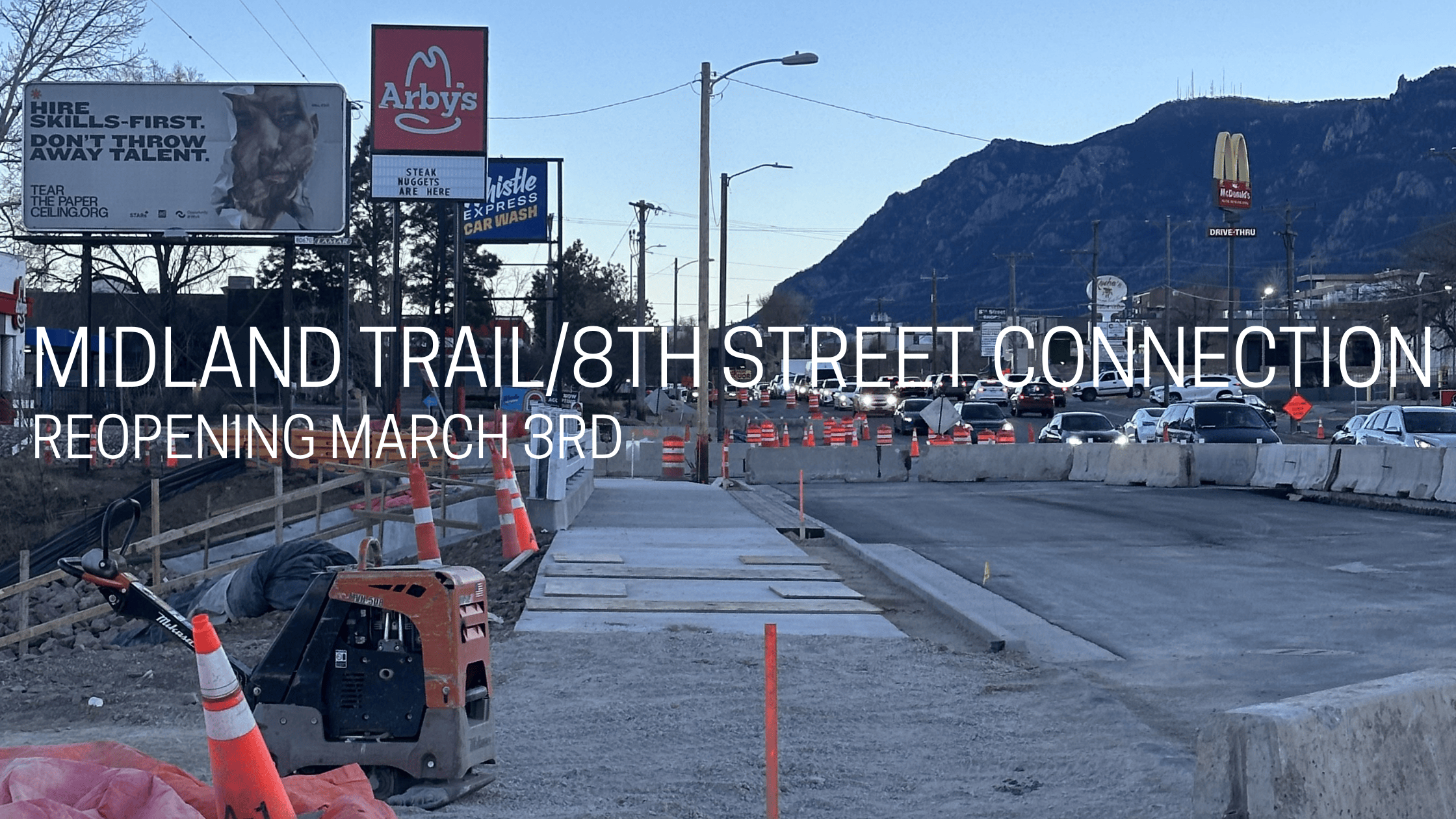
8th Street Midland Trail Connection Reopening
The wait is almost over! The 8th Street / Midland Trail connection is officially set to reopen the evening of Tuesday, March 3rd. This is great restored connectivity for the westside between the Midland Trail and the 8th Street corridor. The all new bridge expansion includes a multi-use sidewalk on the east side of the bridge is finally ready for your tires! We’ve been following this project since it kicked off! Refresh your memory on the project background and the long-term vision here - 8th street project beginning What’s Changing? Starting around 7 p.m. on Tuesday: The Connection: The new multi-use sidewalk on the east side of the Fountain Creek bridge opens!Traffic Shift: Vehicles will shift to the outside lanes (one lane Northbound, two lanes Southbound) so crews can finish rehabilitation work on the center of the bridge.Frontage Road: The eastbound frontage road from 8th St to Hwy 24 will also be back in action. The First Step of Many This new section of the bridge reopening is just the beginning. This is the first in a series of improvements coming to 8th Street for people who bike and walk! Future phases of the 8th Street project will including buffered bike lanes and improved sidewalks to improve comfort and enhance safety for all users. 8th street repaving scheduled to begin Spring 2026. Ride Safe Construction is still ongoing in the center lanes. Keep a sharp eye out for crews and equipment as you navigate the new bridge section. This phase is expected to last about 2-3 weeks, so let’s stay alert while enjoying the new access. Stay Updated For official city alerts and the latest updates, visit: ColoradoSprings.gov/8thstreet
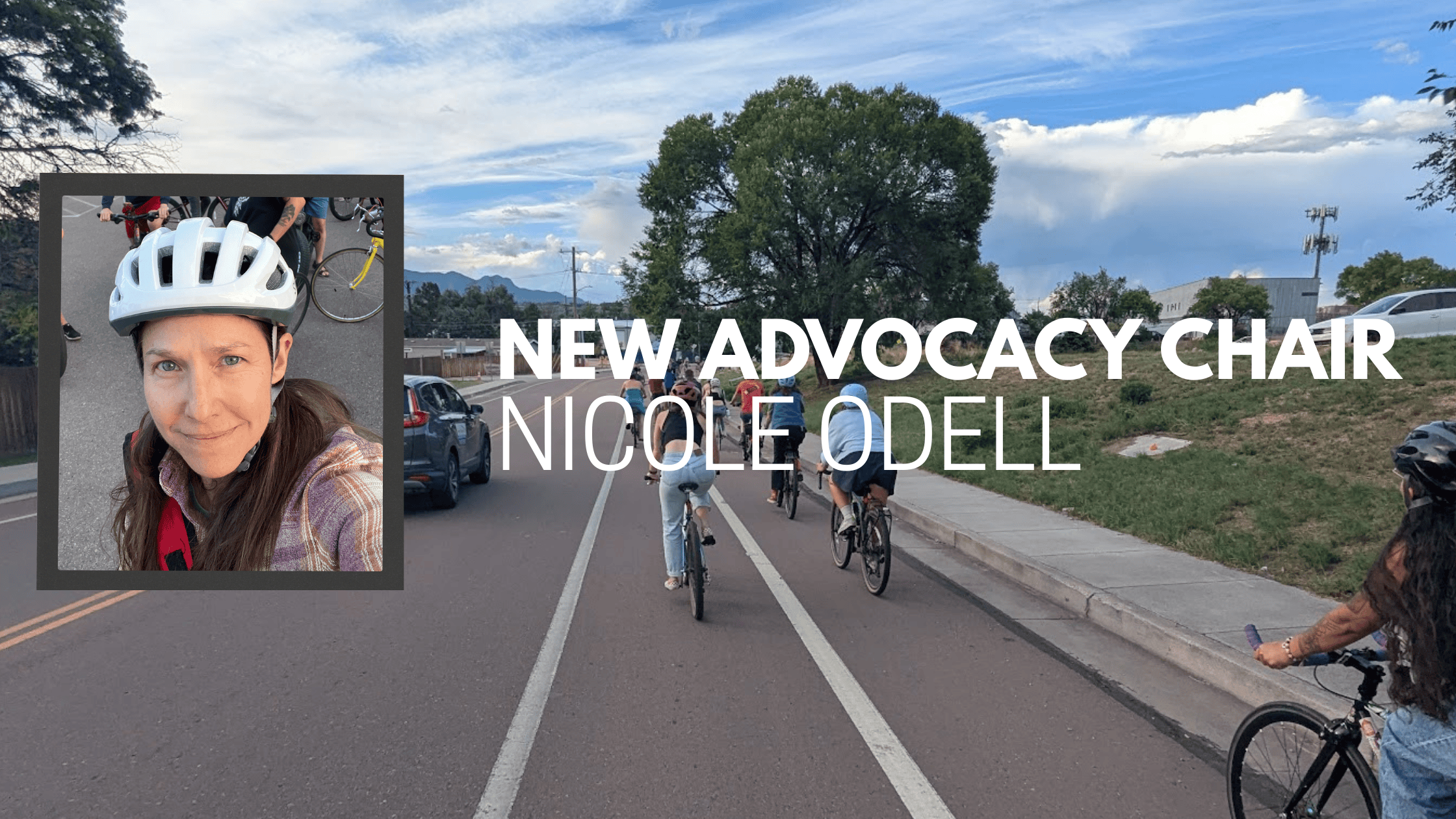
Meet Nicole Odell, Our New Advocacy Chair and Get Involved
We are excited to announce that Nicole Odell, PhD, is moving into the role of Advocacy Committee Chair for Bike Colorado Springs. A resident of the Springs since 2004, Nicole is back in the Pikes Peak region after completing her doctoral studies at NC State University. Nicole’s commitment to our community is well-established, and she returns with a specific set of tools to help us engage more effectively with our city. Read Nicole’s full bio posted on our About Us Page Honoring Jerry’s Continued Commitment As Nicole steps in, we heartily thank Jerry White for his six years of dedicated service as Advocacy Committee Chair. In addition to Jerry's committee chair role, he was integral in securing Bike COS status as an independent 501(c)(3) organization, a milestone that has been foundational to our success. While he is stepping down from the committee chair role, we are grateful that Jerry will continue to remain deeply involved with Bike Colorado Springs as a Board Member and Treasurer. A Great Opportunity to Join Bike COS If you are passionate about making our city better, now is the time to get involved. How you can help: Volunteer: Check our available roles and reach out if you can help. If you see a gap we aren’t filling, tell us—we can work together to define a new role that moves the needle.Write to City Council or Staff: Do you have a project you love or one that needs a rethink? Let City Council or Public Works staff know. Please CC us at info@bikecoloradosprings.org so we can track what’s important to the community and back you up. - How to Voice Your Support PageStay Informed: Keep an eye on our social media (Instagram - Facebook - Cycle the springs FB Group). We are even looking into firing up our email newsletter again to make sure you never miss a critical update. Stay tuned for more updates on our strategic roadmap and consider joining us in shaping the future of Colorado Springs.
Shape the 2026 COS Park System Master Plan
Take Parks Master Plan Visioning Survey - Closing Friday Feb 13! This summer the Colorado Springs Parks Department kicked off their once-in-a-decade Park System Master Plan. This document will guide the future of our outdoor spaces for the next 10–15 years, replacing the outdated 2014 plan. The city has launched their 2nd survey in the yearlong masterplan process - survey closes Friday February 13th . We shared the start of this process in our 1st post when they kicked off their master planning process. Survey close Feb 13 Map from 2014 parks master plan - Link to PDF Here https://vimeo.com/1145793292/c0b1eff738?fl=pl&fe=cm This survey concludes the first part of the Parks System Master Plan which is the assessment, above is a 20min video recapping the assessment findings. Linked here is the full Draft Park System assessment document, a 68 page document highlight the current state of our parks & Rec system in Colorado Springs. This new plan will replace the 2014 Parks Master Plan, making your input vital in shaping the future of our beloved outdoor spaces.Bike Colorado Springs believes this master plan provides a critical opportunity to identify our city's urban trail network as a vital piece of our city's transportation infrastructure. We advocate for our urban trails to have the same standards of connectivity, signage, redundancy, and maintenance as other transportation networks. What to Advocate For: When you participate, consider asking for: Enhanced Urban Trail Connectivity: Advocate for more seamless and comprehensive connections within our urban trail network.Integrated Network Connectivity: Push for clear and safe connections that link our urban trails directly to our on-street bicycle lanes and sidewalk networks, creating a truly unified active transportation system.Improved Wayfinding and Signage: Request consistent, intuitive, and highly visible signage that guides users not only along trails but also smoothly transitions them to and from the on-street bicycle and sidewalk networks.Redundancy for Reliability: Highlight the need for multiple safe and accessible routes to common destinations, providing alternatives in case of closures or maintenance on any part of the network - See USAFA Trail ClosureHigh Maintenance Standards: The Parks Department already does a great job maintaining many of our parks and trails. Let's make sure we continue this excellent work and extend these high standards to all components of our active transportation network – urban trails, bike lanes, and sidewalks – ensuring they are safe, smooth, and accessible for all users year-round. Let's work together to ensure Colorado Springs' parks, recreational facilities, and vital urban trails continue to be outstanding for all residents and visitors. Share this post to encourage others to participate!

Colorado Springs Renewed as Silver Bicycle Friendly Community for 2026
We are proud to announce that the League of American Bicyclists has officially renewed Colorado Springs as a Silver Bicycle Friendly Community (BFC)! 2025 Bicycle Friendly Community Report CardUpdate 4/3/2026 - The League has published our official BFC Report Card, we have linked to the 2025 Report Card below, stay tuned for an upcoming post, we will share those insights here to highlight our strengths and identify where we can continue to improve.2025 Colorado Springs BFC Scorecard This renewal is more than just a title; it is a reflection of our city's long-term commitment to building a best-in-class transportation system. Since first achieving the Silver in 2017 and having our Silver designation renewed in 2021, Colorado Springs has continued to evolve, striving to be a place where everyone, residents and visitors alike, can navigate our community safely and easily by bike. A Growing National Movement “Building better places to bike is a shared effort,” said Bill Nesper, executive director of the League of American Bicyclists. “The communities recognized here are part of a growing national movement, taking practical steps to support bicycling as a safe, accessible, and valuable part of everyday life.” Today, we are proud to be among 444 communities across the United States that are transforming the American landscape, one bike lane at a time. Evidence of Progress The Silver BFC award recognizes the tangible investments Colorado Springs has made in bike education, pro-bike policies, and a culture that celebrates cycling. Key milestones contributing to this renewal include: Community & Culture: The continued expansion of our Bike to Work Day celebrations and the incredible growth of local cycling groups, such as the Wednesday Ride. We've also seen the growth and impact of partners like PikeRide, our local non-profit electric bike share, and Kids on Bikes, which empowers the next generation of riders through education and access.Trail Connectivity: Completing the northern (Rock Island Trail) Legacy Loop connection, paving the west side of the Pikes Peak Greenway, and repaving the Sinton Trail.On-Street Safety: Implementing the Oro Blanco, Wooten Rd, and Fountain Boulevard buffered bike lanes plus, the Pikes Peak Avenue bike boulevard improvements. What’s Next: Updating the Vision While we celebrate this milestone, we are already looking toward the future. The City of Colorado Springs will use the detailed analysis from this assessment to reevaluate COS Bikes!, our city’s bike master plan. Last updated in 2018, an updated master plan will ensure our infrastructure and programs keep pace with our growing community. BFC Report Card Update 4/3/2026 - The League has published our official BFC Report Card, we have linked to the 2025 Report Card below, stay tuned for an upcoming post, we will share those insights here to highlight our strengths and identify where we can continue to improve.NEW - 2025 Colorado Springs BFC Scorecard2021 Colorado Springs BFC Scorecard2017 Colorado Springs BFC Scorecard Learn more about the League’s Bicycle Friendly Community program at bikeleague.org/community.